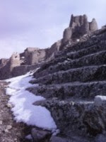
South of Van (I): Diocletian's Castle (?)

Gayda Valley, Gerzevil Mt. Photo by Mahmut Ozdemir
To the traveler, Anatolia means mountains. Not literally, of course: in Greek the word means "dawn," or "place of the dawn," much as the Levant, from the French, denotes a place where the sun is "rising." But if you set a person down anywhere in Anatolia and order him to check all the points of the compass, it is unlikely that he can proceed thirty miles in any direction without encountering either a mountain or, at the least, a very high hill. Truly, they define the country.Unlike the Americas, with the Andes, the Rockies, and the Sierras, Turkey has few distinct and linear mountain ranges. It might be said that the entire country is one big mountain range, extending into the Greek Islands (which are a sunken range) and on into mainland Greece and the Balkans. Even the Taurus, certainly a discrete range between Konya and the Mediterranean, begins in a mass of peaks by the Aegean and disperses into an undifferentiated jumble as it proceeds eastward. But if there are not ranges, there are certainly massifs galore, rugged regions where outside travelers have rarely explored and only the local people (or PKK guerrillas and their pursuers) know their way around.
Such a place lies south of Van, the massive high-altitude lake that is one of the jewels of eastern Turkey. Lake Van (alt. 1648 m., approx. 5400 ft) lies in the middle of mountains and was formed by a mountain--Nemrut Dağı, the extinct volcano whose lava flows at the west end sealed off a valley (aeons ago) and prevented all that water (its max. depth is 451 m., almost 1500 ft.) from joining with the Tigris. South of the lake are more mountains, and it is among those that the photograph above was taken.
I cannot understate my admiration for this picture, a perfect assemblage of light and shadow recorded by Mahmut Özdemir, a school teacher in Hizan, Bitlis. Mahmut Bey knows what he's doing, as anyone can see in the gallery of beautiful pictures posted here. His photographs represent that massive widening of human perspective made possible by digital cameras and the Internet. In previous posts I have displayed photos taken by PKK guerrillas during their wanderings. By posting these the guerrillas have provided a startling look at places that very few people could ever see. The Turkish government, for those who bother to look, is doing the same thing, as are an abundance of new online Turkish newspapers which concentrate on news at the local level. All Turkish provinces, and most sub-provinces, maintain websites, and all of them, like the online newspapers, sport a "Foto Galeri" devoted to local images. Like the PKK's images, much of the content of the government websites is public relations (or propaganda, to those on the other side). But that doesn't mean it is without value. Only by wading through scores of poor and mediocre photographs can you find jewels like the one above.
Mahmut Bey's photo shows Gerzevil Dağı and the Gayda valley, a sparsely populated corner of Bitlis province, south of Lake Van. This unknown valley is as good a place as any to begin the story of lands that few outsiders have traversed.
My story begins with Wigram. In The Cradle of Mankind (1911 and later editions), W.A. Wigram, a priest and emissary of the Church of England, wrote one of the defining accounts of Central Kurdistan and the "Nestorian" (or "Assyrian") Christian mountaineers, who inhabited the high mountains of Hakkari, near what is now the Iraqi-Turkish border. Wigram also wrote about the area south of Lake Van, and in doing so he raised questions that have intrigued me for years. The English travel writer Freya Stark referred to one of them in her book Riding to the Tigris (1958). In The Cradle of Mankind, Wigram refers to the ruins of an ancient fortress, laid out in a perfect square of the Roman type, which lies "somewhat to the west of the Urmi-Van road." Here, in its entirety, is the paragraph:
Somewhat to the west of the Urmi-Van road, and up among the highest of the mountains, stands one interesting memorial of the past. One particular valley runs down from the edge of lake Van to the Tigris; a pass open practically all the year round, between the plain of Mesopotamia and the Armenian plateau. It should be a highroad for commerce; but the Kurds who live in it are too turbulent to allow any traveller to pass that way as a rule, and it is very little known in consequence. It was a passage of strategic importance, however, in the days when Rome held Nisibis as her frontier post on the Persian border; and when Armenia was a buffer state of most uncertain loyalty, between the Roman and Sassanid Persian empires. Hence it was a road to guard; and Roman engineers planted upon it one of the grandest of Roman fortresses, which stands to this day practically unruined. Diocletian, who fortified this strategic frontier, was probably its builder; and it must have been evacuated when Jovian ceded the provinces to Persia some fifty years after his day. Since then it has remained derelict, for anyone to occupy who cared; and so it stands still-one of the grandest Roman relics anywhere.The "Urmi-Van" road, an ancient caravan track, still is the main highway between Van, in Turkey, and Urmia [Urumiyeh] in Iran. He mentions having visited this ruin in the company of the English military consul in Van and says that the local Kurds had taken it over, building their stone houses in the rubble. Freya Stark, referring to this Roman castle and the nebulous directions given by Wigram, confessed her bewilderment at where it could be.
In 1979, provoked by this mystery (so minor that it might be called a mysterette), I too got into the act. I knew that Freya Stark was still alive, and I knew that she lived in Asolo, in northern Italy. I had no other address for her, but I wrote a letter anyway. Had anyone found this fortress? I asked. Did she have any further clues about where it might be? I included kind words, of course, and the necessary apologies for having intruded. At the time Freya Stark was 86 years old--she would live to 100--and of course I expected no reply at all.
Still, there it is, a sheet of light blue airmail stationery with a printed address, pasted in one of my old notebooks. The date is handwritten: 10/3/79 (10 March 1979). The address says, "Via Canova, Asolo; Treviso. Tel. 52732". Dear Mr Taylor, it begins,
I should be so delighted if you could find that Roman fortress. All I can tell you is that it is not along the track from Julamerk [i.e., Hakkari] to the Tigris along which I rode, & that it was not found by the young Scot who was Captain of HMS Mercury & went hunting about for it in that tangle of the Kurdish hills. It must of course be on one of the tracks that wind among the tangle of valleys that mark the Iraqi-Persian border (unsafe just now I should say).Who this Scotsman was, I cannot say, but I do know that his "ship", HMS Mercury, was in fact a "stone frigate", a shore station for signals training, and not a floating vessel. Dame Freya is certainly off the mark when she says that the fortress "must of course" be among the valleys that mark the Iraqi-Persian border. Those valleys are not "somewhat to the west" of the road mentioned by Wigram; they are east of it. In fact, as I now believe, the "Roman fortress" mentioned by Wigram is at the western end of Lake Van, very close to Mahmut Özdemir's home.
The critical clue comes from that young military consul mentioned offhandedly by Wigram. After the Russo-Turkish War of 1877-78, the Ottoman government was forced to accept the presence of British military consuls in its eastern provinces. Their job, ostensibly, was to observe the Turks' adherence to the Treaty of Berlin, especially their treatment of religious minorities (i.e., Armenians). For obvious reasons, the presence of these officers became a great source of humiliation to Turkish nationalists. In fact, these consuls, like other members of the English aristocracy, were in general more sympathetic to the Muslims than they were to the Armenians. Greater scholars than I will know about the political work of these men; I am concerned about the time they took for that most English of hobbies, Oriental exploration.
Two English consuls (that I know of; there may have been others) published excellent articles about their journeys in Kurdistan between 1878 and 1914. The first, Capt. F.R. Maunsell, R.A., read papers at the Royal Geographical Society in 1894 and 1901. His 1901 paper, "Central Kurdistan," is available online through jstor.org. He drew wonderful maps as well, and one of them can be found at the University of California-Berkeley library, where I obtained a photocopy in 1976. [Note: Maunsell called this area "Central" Kurdistan; the subtitle of Wigram's book refers to it as "Eastern" Kurdistan; and modern Kurdish nationalists call it "Northern" Kurdistan. I have no opinion on the matter.]
It is a second consul, however, that W.A. Wigram would have known. Capt. Bertram Dickson, R.A., appears to have succeeded Maunsell as British consul in Van. Like Maunsell, Dickson explored the region and presented a paper about his travels at the Royal Geographical Society. Unlike Maunsell, however, he took photographs, one of which was used in my book Fever and Thirst. His article "Journeys in Kurdistan", published in the Geographical Journal of April 1910, puts to rest once and for all any mystery about Wigram's Roman castle.
Jezire and Mukus were Roman outpost provinces in the time of Diocletian [A.D. 284-305], and it is interesting, while travelling, to pick out traces of their occupation. In the picturesque valley of Khizan [Hizan] is what I believe to be a Roman fortress, in a wonderful state of preservation; this may very possibly have been the capital of the Roman capital of Moxene, lying between the buffer states of Armenia and Mesopotamia.Jezire (Cizre) is near the Iraqi border, on the Tigris. Mukus, a village near Hizan, is an obvious derivation from Moxene (or Moxoene), a province of ancient Armenia. It retained its ancient name (Müküs) on Turkish maps until the 1980s, when the government map-makers in Ankara Turkified it into its present name, Bahçesaray. Dickson is obviously speaking about the same fortress as Wigram. Rev. Wigram says this about their visit:
The writer once visited the spot, in company with the British military Consul of Van; being attracted both by the interest of the building itself, and also by a story that there was a hoard of ancient documents in some unknown tongue in one of the rooms of the castle. The tale is quite probably true, though the documents may be of any date; but the present owner of the place politely denied all knowledge of them. His guest was a marvel of erudition, he declared, but had been misinformed in this particular; and so he changed the subject to something that interested him more. This was the Consul's Mannlicher rifle, a beautiful tool that always excited envy everywhere, and was invaluable as a topic of conversation. Our host examined it, dandled it, played with it; and finally proposed a fair exchange-that rifle against his newly married wife! A deal which the Englishman rather ungallantly declined.Both Dickson and Wigram relate that the local Kurds built their homes ("hovels" is the actual word used) in the walls of the castle using its stones. Dickson describes the castle at length (250 yards square, walls originally about 25 feet high and 15-20 feet thick, with towers), leaving no doubt about its reality. The reference to Diocletian makes sense as well, for that Roman emperor spent much of his rule living in Asia Minor (in Nicomedia, now Izmit, near Istanbul), visiting Rome only once. (There is no record, however, that he ever visited this particular fortress in Armenia.) Before the end of the 3rd century, the Roman general Galerius fought a major war with the Persian Empire to regain control of Armenia, their client state, and this remote province would have been near the center of the action. External threats loomed everywhere in Rome's waning centuries. The building of fortifications in the Empire's borderlands was a major preoccupation of Diocletian during his twenty-one years as Emperor, as Freya Stark notes in her Rome on the Euphrates. In eastern Asia Minor, she writes (p. 305),
"[T]he number of troops was more than quadrupled and the accent was placed on forts and garrisons. The diminished legions were multiplied to about sixty, and new and smaller ones with effectives of one thousand men were created. Early in the fourth century we find them still based on Melitene [Malatya] and Satala [Gümüşhane], on Trebizond [Trabzon] for the Black Sea convoys, and in Armenia. [my emphases]Obviously Dickson and Wigram are on the right track. If it looked like a Roman fortress, and was laid out like a Roman fortress, it probably was a Roman fortress. Hizan is not, strictly speaking, along an easy, direct route to the Bohtan Su, the river Centrites of ancient times, which would quickly take the traveler to the Tigris and Mesopotamia. Still, it possessed one advantage for an army garrison in those remote valleys: it provided sustenance.

This, in another Mahmut Özdemir photo, is Hizan (the Gayda valley) today. It is the kind of place where grain could grow, and where you could quarter a sizable garrison. It only remains to show another photograph, not by Mahmut Özdemir but by Jelle Verheij, a Dutch scholar and historian who has a knack for going to exactly the places that I want to go. Here is his photo of what I believe to be Wigram and Dickson's Roman fortress:

This is Eski (Old) Hizan, and the place, according to Jelle Verheij, is called Kayalar (lit., Rocks) by the locals. The tower is there, as the English travelers described, as are the Kurds' houses built among the ruins. I can find no other photos that give a sense of the fortress's size. Still, it seems obvious that this is Wigram's Roman castle, wondered about by Freya Stark and now found through the invention of digital cameras and the Internet.
In my next post I will explore further this area south of Lake Van, beginning with the Roman general Lucullus and possibly earlier, with a mountain-top shrine that so far is undocumented.
Addendum. Pursuant to comments, please note: For further information, see the Wikipedia article about Roman concrete: http://en.wikipedia.org/wiki/Roman_concrete. In the article it specifically mentions that the concrete was seldom left bare and always had a facing on it. Among the facings mentioned was Roman brick set in a herringbone pattern. Now look at Jelle Verheij's photo again. Are those stones? Or are they Roman bricks that have eroded into irregular shapes? Either way it seems likely that this is Roman concrete construction. Among other things, how else would it have lasted so long? Further comments welcome.
Labels: Bertram Dickson, Diocletian, F.R. Maunsell, Freya Stark, Hizan, Jelle Verheij, Kurdistan, Mahmut Ozdemir, Rome, Turkey, Van, W.A. Wigram
posted by Gordon Taylor at
1:45 AM
14 Comments
![]()
![]()

